

Your camera measured the run. Orbitrace writes it into the picture.
Insta360 X3 to X5, GoPro HERO5 to HERO13 (except the HERO12, which has no GPS) and DJI drones record GPS and motion sensors alongside the footage. Orbitrace reads that data on your computer and burns it into the video as instruments.
€80 once, €199 after launch · macOS and Windows
Buy Orbitrace — €80Below, a jump replays frame by frame as you scroll.
Approach. The camera’s GPS gives speed and heading. Orbitrace smooths the track and lines it up with the footage, frame by frame.
Take-off at 5.00 s. The accelerometer drops below 0.35 g: the camera is in free fall, the jump timer starts.
1.41 s in the air. The gyroscope adds up the rotation: 359° by the landing.
Landing at 6.41 s. Peak of 3.4 g on the accelerometer. The jump lands in the Moments tab, ready to export.
The export. The same instruments, burned into an MP4 by the app at source quality. This is the file you post.
GoPro footage. The GPS track and motion data are synthetic, lined up by hand on this video to show the rendering: the values do not describe this jump.


What your camera already records
No sensor to add. These devices write telemetry inside the video file or next to it, and Orbitrace reads it as is.
| Device | Models | GPS | IMU | File | Good to know |
|---|---|---|---|---|---|
| Insta360 | X3 · X4 · X5 | GPS | IMU | .insv | GPS through the GPS remote or the phone app. |
| GoPro | HERO5 → HERO13 · MAX | GPS | IMU | .mp4 | The HERO12 has no GPS: pair it with a GPX. |
| DJI | Mavic · Air · Mini | GPS | — | .mp4 + .srt | Turn on video captions on the drone. |
| GPX | Garmin · Strava · Apple | GPS | — | .gpx | Attach it to any video recorded at the same time. |
The instrument panel
Each gauge sits on your actual frame. Drag it, size it, save the layout as a preset for the next ride.
 1
2
3
1
2
3
- Attitude indicator
Roll and pitch from the gyroscope, read like an aircraft instrument. It follows full rotations.
- G-force
Lateral and longitudinal acceleration: braking, cornering, landings.
- Lean angle
Motorcycle lean computed from the GPS, whatever the camera mount, with left and right records.
-
 Map
MapRound or square; street, dark or satellite. North-up, or turning with your heading, degrees on the compass ring.
Also: speed dial or counter, altitude and its curve, grade, GPS coordinates, date and time.
Landscape, square or vertical
Gauges are placed in proportion to the frame. Export in 16:9, square or 9:16 for Reels and Shorts: they stay where you put them. Encoding uses your graphics hardware.

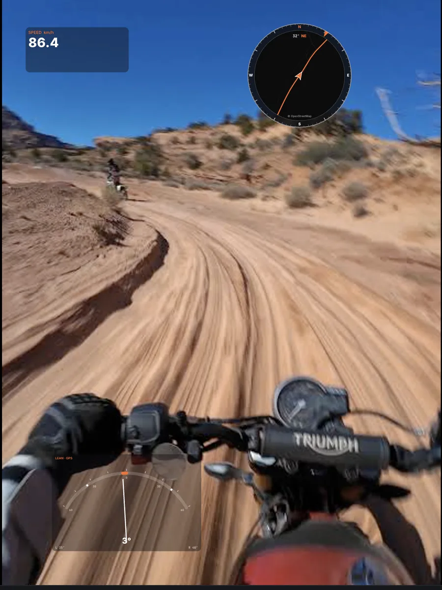
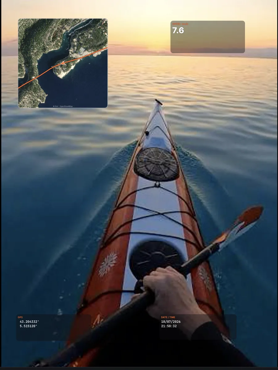
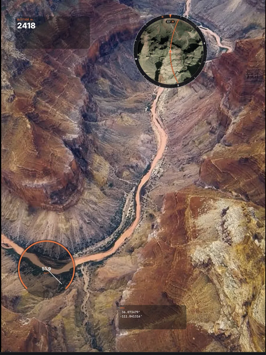
Screens produced by the app on demo footage and demo tracks.
Highlights, found in the data
Orbitrace goes through the whole file and lists what stands out. One click exports the few seconds around it.
1.41sairtime on the jump above, free fall read on the accelerometer
51.9km/htop speed of the same clip, from the GPS
Speed, km/h · time, s · demo data
What gets detected
- Top speed
- Maximum lean, left or right
- Jumps, with airtime
- Peak G-force
- Steepest descent and climb over 20 s
- HiLight tags pressed on a GoPro while filming
Every ride on one map
Point Orbitrace at your SD card or a folder: it reads every video, draws each track and lets you sort them into folders. Drag the divider to switch from street map to satellite.
150 demo routes around Lake Annecy.

 MapSatellite
On your computer, offline
No video leaves your machine. The Internet is only used to activate the licence and load map tiles.
- Trim
- The whole ride or just the best 20 seconds.
- Sync
- Shift the telemetry by ±1 frame against an edited video.
- Insta360 Studio
- Reframe in Studio; Orbitrace finds the MP4 next to your .insv and pairs it with its telemetry.
- Quality
- Source quality, original audio kept, no watermark.
- Encoders
- Apple VideoToolbox, NVIDIA, Intel, AMD.
- Playback
- Native 8K 360° playback.
- Systems
- macOS Apple Silicon and Intel, Windows 10 and 11.

Lifetime licence
€80
Launch price. It goes up to €199 after launch.
Buy Orbitrace — €80Secure checkout · VAT handled for your country
- Computers
- 2, Mac or Windows
- Updates
- 1 year included
- Subscription
- None, you pay once
- Watermark
- None
- Cloud
- None, everything stays on your computer
- Features
- All of them: maps, instruments, highlights, export
- Delivery
- Immediate: download link and licence key by email
Questions
- Which cameras are supported?
- Insta360 X3, X4 and X5 (.insv), GoPro HERO5 to HERO13 and MAX (.mp4), DJI drones with their .srt captions, and any GPX file from a watch, bike computer or phone.
- Do I need a 360° camera?
- No. Orbitrace works with regular videos too. No GPS in your camera? Attach a GPX recorded at the same time.
- Can I reframe my 360° video in Orbitrace?
- Reframe in Insta360 Studio (it’s free and excellent), export the MP4, and Orbitrace automatically pairs it with the telemetry of your .insv.
- Do my videos get uploaded anywhere?
- Never. Everything happens on your computer. An Internet connection is only needed to activate your licence (and to load map tiles).
- How do I install it?
- After purchase you receive a download link and your key. On Mac, if macOS blocks the first launch, open System Settings → Privacy & Security → “Open Anyway”. On Windows, if SmartScreen appears, click “More info” → “Run anyway”. Then paste your key.
- Can I use it on two computers?
- Yes, your licence activates on 2 computers. Changing computer? Deactivate it in the app and activate it on the new one.
- Is it a subscription?
- No. You pay once and keep the app forever. One year of updates is included.